Queenswood Road Nature Reserve
Note: Some of the information on this page duplicates the Webpage giving the history of Queenswood Road.
The nature reserve takes its name from the adjacent Queenswood Road which only came into existence at the end of the nineteenth century. The nature reserve lies on land (shown on the map as the field on the north side of Perry Mount House.
The nature reserve lies on land which was once part of a farm and later country house called Perry Mount. Uses of the land have never been anything other than agricultural with the added attraction of the remains of the footings of two small farm buildings and their only source of water - a hand pump.
The site is quite unique in concept. Most nature reserves in London have been created from land on which buildings once stood. There is nothing wrong with that but it means that, after clearance, the present flora and fauna are likely to date only from the time of laying out the site. This site has never been built on and many ancient species of plants are likely to still be on the site from possibly centuries back. Apart from a few points around the fringes of the site, no domestic rubbish has ever been dumped on the land and so the condition of the soil is in its original state. The soil, such as it is on the clay base, has never been disturbed other than for agricultural use and the lie of the land has not been altered.
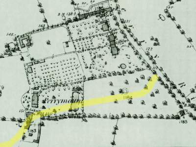
Stanford's map of 1862 showing part of Perry Rise (right) and Perry Mount House with stables and other out-buildings to the south of the house.
Queenswood Road (shown by the pale yellow line) was yet to be laid out. Its curved line runs through the out-buildings and then almost through the centre of the large field.
While many nature reserves have had a 'new start', dating from their laying out after clearance of the land, the land at Queenswood Road can claim to have been an identifiable field on ancient plans for the area. This means that the site, with its gentle slope to the east, remains in tact from its earlier uses, having the feel of a country field from days gone by.
Farm Features
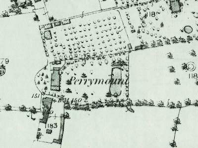
The Nature Reserve occupies much of the field shown with little 'dots' shown in it (in the map above), to the north of Perry Mount House. A larger map of this field is shown beside this text and reveals that the 'dots' are actually rows of fruit trees. At the corner of the field which backs onto Wynel Road were once two small farm buildings, probably sheds.Ditches are clearly shown on the Lewisham Board of Works map, of 1875, and some of them remain in the field to this day.
Some of the hedgerows around the field are ancient. On the west side are two yew trees. One of them fell over in the early 1990s after high winds. Yew trees are known to grow very slowly and both of them could be well over 500 years old, maybe more. They point to the edge of the field being an ancient boundary.
The northern boundary, with the Wynel Road houses and the bowling green, has little to commend it. There are a few large trees but they have rather an urban look to them. In this corner is a modern structure run by Sydenham Garden. Its entrance is in Wynel Road which was the old entrance to the field in the 1960s.
On the eastern side, the hedgerow near the greenhouse is the most countrified of the four. It contains two large fruit trees as well as a multitude of smaller bushes. The fenced part of the land was erected by the developers around 1990 on what had been tennis courts for a private sports centre.
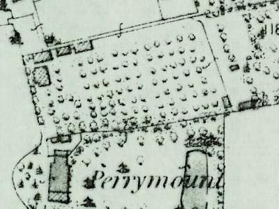
Stanford's map of 1862 showing a close-up of the orchard of Perry Mount House - that has become today's Nature Reserve.
The shaded rectangles in the top left of the orchard are probably brick-built farm buildings. The present greenhouse must be later than the map since it is not shown. Its site would be on the northern side of the orchard, about half-way along.
The Greenhouse
Still in situ is a
greenhouse which is hardly modern and probably dates from Edwardian
times. The sturdy wooden structure shows that it was not a 'take away
and erect it yourself' job. In those days such structures were custom
built on site. The interior has brick retaining walls for soil and a
below-ground level York stone floor. The entrance door is at one end,
with a partition within the structure, also containing a door. In this
greenhouse the owner could have two differing climates within the one
structure - sometimes called a 'hot house' and a 'cool house'.The many panes of glass that had broken were all replaced by removing identical glass from an old greenhouse, owned by Lewisham Council at Brockley, and inserting them into the wooden frames at Queenswood Road. Thanks to the generosity of Dulux, the whole greenhouse was then painted white with undercoat and overcoat. This work was carried out around 1992.
The Cold Frames
Beside the greenhouse, on its south-facing side, is a very old-fashioned row of cold-frames. They are surrounded by their original low brick walls. The dividing walls as built with sloping tops and, when in use for growing vegetables for the cook to use in the large house, they almost certainly had large glass covers, probably mounted in wooden frames. It was usual to hinge the glass covers set beside the greenhouse wall. This made for easy access by the gardener but also allowed the frames to be opened just a few inches to allow any boisture build-up on the glass to disperse to give the plants inside plenty of sunshine which they grew protected from the wind by the low brick walls.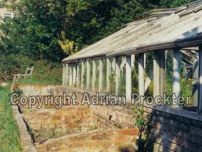
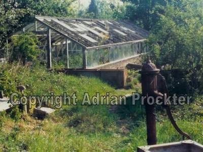
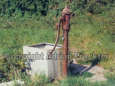
The Hand Pump
Once the only source of water for the farm, stands a hand pump, believed to be one of the last
remaining working pumps in South London. Inspection of the handle
reveals that it has been mended, near the top end. The old man who had a
plant nursery in the 1960s found the handle broken and managed to get
it mended by a local blacksmith. At the top of the main supply shaft is a semi-circular
cover which was found quite by chance while the site
was being cleared. The pump works well. The
valve is best primed by tipping water down it before trying to work it.
The date of erecting the pump is not known but is unlikely to be older
than about 1850.The pump derives its water from an artesian well below ground. Its depth is not known but it is unlikely to be more than 30 feet (9 m).
Perry Mount House
The site of the large farmhouse, later to become a country residence for well-off owners, is well documented on the maps for the area. Sadly, there are no known pictures of the farm or the large house.The house stood to the north of today's Queenswood Road, at the bend where No 21 stands. We are fortunate in having a complete list of owners of the property, constructed by staff at the Lewisham Local History Library. We are most grateful to the staff for making this list.
1794 - House built, then called Perry Vale Farm. The name appears in documents dated 1849 and 1855. The house was built in 1794, maybe shortly before, to take over the Mayow land, previously farmed from the Dolphin PH, a pub still in Sydenham Road today.
1820 - Around 1820 the farmhouse was enlarged. It appears that after the old farmhouse was enlarged and improved, probably by W D Adams, a smaller house was built just to the south. This may account for the period of joint occupation in the 1840s.
1851 - Called Perry Mount House.
1857 - Called Perry Mount or Perrymount. The name appears as ‘Perry Mount’ or ‘Perrymount’ from 1857, apart from a document of 1861.
1861 - Called Perry Rise Farm.
1897 - Farm building demolished. The small house and other farm buildings were demolished about 1897, when Queenswood Road was created. The only survivor was the building opposite Nos 13-21 Queenswood Road.
1900 - About 1900 the house was known as 39 Mayow Road.
1937 - The house was demolished.
1988 - About 1988 the stables, later used as garages, with living accommodation above, which had been the coach-house to Perry Mount House, were converted into a terrace of three small houses a developers.
Now - No trace of the old house remains. The Nature Reserve and the three small houses are the only evidence for the original estate. (Pictures and more details of the three small houses can be seen under the Webpage about Queenswood Road).
