Queenswood Road
It might seem that the name of this road is highly relevant, bearing in mind that we are talking about a location surrounded by forest. However, although the name may well be appropriate - even grand - there is no local reason why the name has arisen.
As far as the 'queen' is concerned, the closest connection with royalty is the fact that round the corner is a pub named the Prince of Wales, which is a very common pub name, found all over London and also throughout England.
The 'wood' is appropriate only because much of the surrounding land was woodland. 'Queenswood' is not an ancient local name. While on the subject, Westwood Hill, not far from Sydenham Station, is named after the 'West Wood' which was part of the larger Great North Wood.
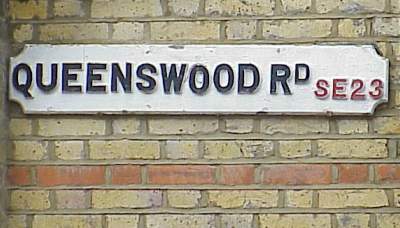
The post-1920 name plate at the junction with Mayow Road
It does not appear that Queenswood Road can claim any direct relevance to the Great North Wood. Having dealt with its name, we will consider the history surrounding the road.
The Line of the Road
Proposals for Queenswood Road are to be found on a map dated 21 December 1896 (see map on right).
The first houses were erected on the sloping part of the road, leading up from Perry Rise. That must have been some time during 1897 or later. Larger houses lining the flatter part of Queenswood Road, from where it joins Mayow Road are Edwardian, probably built around 1910.
Once the connecting section of the road was completed and Perrymount House had been demolished, a curve of semi-detached houses were added beside the newly formed roadway. They were ready to be sold in 1938.
Today the road contains no less than three tight bends along its relatively short distance. The only other change in the road is the addition of a cul-de-sac called Holland Drive in the 1980s.
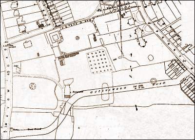
Map dated 21 December 1899, showing the newly proposed line of Queenswood Road (towards the lower edge of the map. Mayow Road runs along the left-hand edge and a short piece of Perry Hill is to be seen near the top right-hand corner.
Perrymount House
A large house, called 'Perrymount' or 'Perry Mount' was built in the early 1790s. Its approximate site was where the houses and gardens of Nos 21-27 now stand (see map). The house stood in extensive grounds, which included an orchard, a kitchen-garden, green-houses and stables.
Sadly, no pictures of the property are known to exist. All this information about its position has been deduced from old large-scale Ordnance Survey maps. The house can also be seen on the smaller scale map (see previous heading).
A curved drive is shown, leading to the house from Mayow Road so we may assume that the 'front' of the house faced west (towards Mayow Road). On earlier maps a path to the house is shown leading off Perry Rise.
South of the house are three out-buildings are shown. One of them (coloured in orange) still remains. It was the stables and was still recognisable as such in the 1980s before being converted into three small houses.
It can be seen that the alignment of the new road was carefully drawn to leave both the great house and the stable-block both standing. That was not to be and house was demolished by 1937 to make way for the semi-detached houses now numbered 15-31 in Queenswood Road.
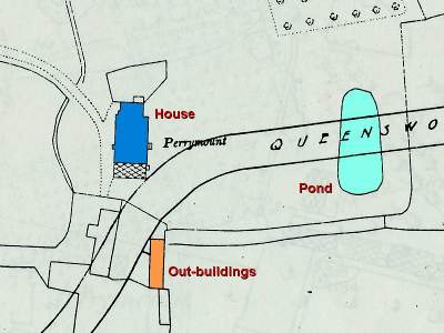
Detailed map dated 1895, showing Perrymount House (dark blue) with a glass conservatory on its southern side (shown cross-hatched). Notice that the property had a large pond (pale blue) whose site would now lie across the sloping part of Queenswood Road.
Perrymount Estate
Having explained what happened to the site of the house, we now take a look at what happened to the rest of the estate. The land of Perrymount House was a large piece of land that had very limited access. By looking at a modern street map of the area it can be seen that this land is bounded by Mayow Road (to the west), Queenswood Road (on the southern side), Perry Rise (to the east) and the unusual feature of Shaw's Cottages (on the northern side). Shaw's Cottages and its western continuation is a foot-path bringing the pedestrian out along the southern 'leg' of Wynell Road.
Over the years, various developers have made 'in-roads' into the land-locked ground. This will now be described.
The semi-detached houses (15-31 Queensood Road) were built as a development of ten properties. Numbers 17-19, 21-23, 25-27 and 29-31 are semi-detached, with 15 being in the same style but built as a detached residence. That accounts for nine houses. The tenth property was also a detached 'semi', built NW of (behind) the other nine, with access from Mayow Road via a long drive.
In the 1970s a developer bought the lone house, which gave access to that property which had a very large rear garden. Two of the large houses on Mayow Road were also acquired, along with their long rear gardens. Those three properties provided enough space to build April Glen, with three rows of 'town houses', as they are today. One of the old white stone gate-posts can still be seen beside the the pavement of Mayow Road. This was beside the entrance to the long drive to the tenth semi-detached house just mentioned.
During the Second World War Number 43 Queenswood Road was totally destroyed. This left a gap which provided access for a developer called Holland to start erecting houses behind the north side of Queenswood Road in the 1980s. A few houses were built beside a short access cul-de-sac called Holland Drive.
The rest of the land that had been the orchard and kitchen-garden of Perrymount House was land-locked. There was a private drive on the south side of the Prince of Wales pub which gave access to the land. Until the 1970s, this land was used as a private sports club consisting of a brick-built club house, several tennis courts and the unusual feature of an open-air swimming pool. Those who used it said it was like being in the heart of the countryside because the location was so peaceful. By the 1980s, membership of the club had declined and it was closed. Gradually all the facilities were 'overtaken' by nature - as well as suffering considerable vandalism.
The developers Charles Church purchased all the remaining land but were stopped in their tracks by a very determined Lewisham Council who insisted that part of the land be handed over to the borough for a nature reserve. The Queenswood Road residents, adjacent to the land, we delighted and set about clearing the allocated land. The new housing development on the reduced remaining land used access from Perry Rise, where another house was removed to erect Paxton Road.
The Nature Reserve enclosed land which had been the old greenhouse, cold-frames and orchard of Perrymount House.
The long greenhouse (Image C) was restored and re-glazed. Glass was removed from another greenhouse that was about for be demolished and the glazing was therefore able to be installed. The original method used on this greenhouse was just to lay the panes of glass in the wooden grooves and insert galvanised clips to prevent the glass from sliding down the roof.
The cold-frames (Image C) were cleared of rubbish and overgrown weeds. These were in a very poor state when they were found. They required considerable clearing.
The gem that was remained from the days of the old house was a working hand-pump (Image A). The land on which it stood had been a plant nursery, in the 1960s, run by an old gentleman who sold roses and other flowers on a large plot of land, watering it by using the hand-pump and a watering can! Access to that land was via a narrow drive off Wynel Road.
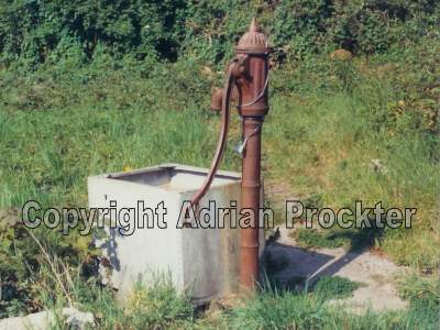
Image A: The pump in 1988, when a start was made on clearing the land for the Nature Reserve.
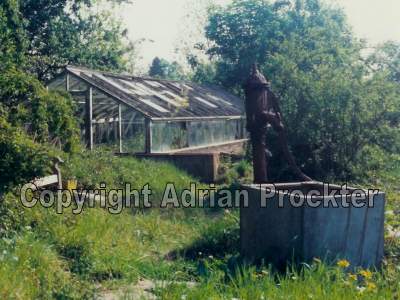
Image B: The pump, seen from the opposite direction, with the long greenhouse in the background. It is most likely that the greenhouse provided food for the residents of Perrymount House.
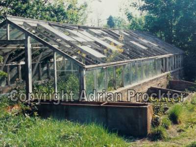
Image C: The greenhouse with the cold frames beside it. Notice the glazing on the greenhouse which had almost disappeared - either due to the glass being smashed by vandals or just due to old age.
It is likely that the pump is one of a very few that are still working anywhere in London. It is probably one of Forest Hill's best kept secrets!
The image shows the pump as it was when the land was declared a Nature Reserve in 1988 (Image A). There must be an artesian well below ground, probably only 10 or 20 feet down, since the hand pump would not be able to force water up the pipe from any greater depth. It is likely that, when Perrymount House was first built, in the 1790s, the pump was the only source of water for the house as well as the grounds.
The Nature Reserve is run by London Wildlife Trust, who manage the plants and advise on what needs to be cut down, as well as general maintenance. The 'oasis' surrounded by local streets and houses continues into the 21st century, with its reminders of life over 200 years ago!
It should be noted that access to the land is restricted. Although it is designated a Nature Reserve, that land does not have public access. It is owned by the London Borough of Lewisham.
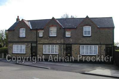
The Stables
The largest surviving feature of the Perrymount Estate is the old stables. Whoever laid out Queenswood Road seemed quite keen to preserve that building. If it was not the case, the awkward double bend at the high part of the road would not be there.
Perrymount House was large, so the owners must have been quite wealthy. It is possible that they kept a coach or carriage in the building, with horses also being stabled there. The stable-lads and/or coach driver may have lived upstairs, as was the custom in those days.
Until the late 1980s the long narrow structure of the coach-house and stables, with living accommodation above, really did look like a countrified building (see picture). Due to years of neglect, the building was in very poor condition.
One person occupied the upper floor which must have been quite cramped. On her death, the property remained unused. It was developed into three small residences and considerably tidied up on the outside.
After reading about Perrymount House and its demise, it is easy to feel nostalgic about its passing into history without ever being documented in the form of a print or photograph. Indeed, it is sad that the developer did not record the property with photographs before commencing work. However, Queenwood Road has a living legacy remaining from the days of the house - in the form of the greenhouses, the pump and the old stables. All three of these items must be quite rare within Inner London today.
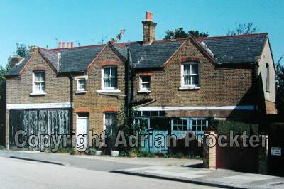
The stables, seen in the 1970s. The white door (at ground level) gave access to a staircase that led to the upper living accommodation. None of the large doors were ever opened during the last 20 or 30 years before the property was redeveloped. The large black doors had given access probably to a coach-house. The blue doors, although they look like garage doors, were probably once used for stabling.
The image below shows the conversion of the building into three houses. All the windows on the first floor are in the same position as before but everything at pavement level has been considerably changed.